No Warnings, Watches, or Advisories

NWS South Mississippi Valley Regional Radar WU South East Satellite
Radar/Satellite images courtesy of NOAA/NWS and Weather Underground.
spacer
METRIC | IMPERIAL
Updated: 27-Jun-2026 @ 2:40pm   (0 sec ago)
Temperature Current Conditions Forecast / Storm Prediction
Currently Outside: Colder 1.1°F than last hour.

87.4°F

Heat Index:  100.1°F
Feels like:  100°F
Warm
High Today
88.9°F
1:36 PM
Low Today
75.8°F
5:53 AM
Yest High
90.4°F
4:04 PM
Yest Low
68.1°F
5:41 AM
Sta* High
100.4°F
2010
Sta* Low
60.1°F
2017
* This Station's Records Since 9/2009
Rec* High
102°F
1952
Rec* Low
52°F
1974
Avg* High
90°F
Avg* Low
69°F
* Records from NOAA
partly cloudy -  Lightning observed partly cloudy - Lightning observed

Calm Wind:  SE
0.0

Gusting to:
0.0 mph
Current Rain Rain:
0.00 in
Chandler Burning Index: LOW Current CBI
Fire Danger:
4.8 of 100
This
Afternoon
This Afternoon: Showers And Thunderstorms Likely
Showers And T-Storms Likely
Tonight

Tonight: Showers And Thunderstorms Likely
Showers And T-Storms Likely
Sunday

Sunday: Chance Showers And Thunderstorms
Chance Showers And T-Storms
Hi 87°F Lo 73°F Hi 93°F
SPC Activity Map
Dew Point Liquid Precipitation Wind Speed Sun/Moon
Current: Decreased 0.5°F since last hour. 76.8°F
Last Hour: Decreased 0.5°F since last hour. -0.5°F
High 1:35 PM: 78.4°F
Low 3:12 AM: 70.9°F
Record High: 78.4°F on
Jun-27-2026
Record Low: 53.6°F on
Jun-15-2026
Wetbulb: 79.9°F
Rain Today
rain graph

Today: 0.00 in
Yesterday: 0.00 in
Last 7 Days: 0.74 in
Jun Rain: 2.57 in
Jun to Date
  Avg:10
4.06 in
Jun to Date
  Diff from Avg:10
Under 1.49 in for the month 1.49 in
Jun Avg: 0.00 in
Diff from Avg: Over 2.57 in for the month 2.57 in
Season:1 18.05 in
YTD
  Avg:11
4.79 in
YTD
  Diff from Avg:11
Over 13.26 in for the year 13.26 in
Last Rain
Time/Date:
Jun-23-2026
at 4:58 AM
62 rain days in 2026
10 days in June
4 days since last rain
Current: SE  0.0 mph
1Hr Average: Calm
Wind Run: 0.10 miles
Wind Gust
Current: 0.0 mph
Today: 14.0 mph 11:45 AM
Month: 15.0 mph Jun-17
Year: 15.0 mph Jun-17
Record Gust: 15.0 mph
Jun-17-2026
Sunlight:
14 h 35 m 14 s
of Sunlight Yesterday
14 h 34 m 56 s
of Sunlight Today
Which is 18 sec shorter than
yesterday
14 h 34 m 35 s
of Sunlight Tomorrow
(Noon ?>) graph (Midnight
Legend

Waxing Gibbous
Waxing Gibbous, 12 days, 16 hours, 47 minutes in cycle
96%
Illuminated
Humidity Barometer
Current: Increased 2% since last hour. 71%
Last Hour: Increased 2% since last hour. 2%
High 5:54 AM: 86%
Low 1:37 PM: 67%
Record High: 95%
Jun-19-2026
Record Low: 42%
Jun-20-2026
Current: Falling 0.033  inHg/hr 30.002 inHg
Last Hour: Falling
High 9:02 AM: 30.078
Low 2:38 PM: 30.001
Record High: 30.173 inHg
Jun-24-2026
Record Low: 29.724 inHg
Jun-17-2026
Cooling Degree Days Snow3 Heat Index Air
Today: 8.4
Jun: 221.5
2026 to Date: 531.6
Heating Degree Days
2026 to Date: 1570.2
Today: 0.00 in
Yesterday: 0.00 in
Jun Snow: No Change 0.00 in
Jun Avg: 0.00 in
Diff from Avg: 0.00 in
Season Total:2 1.50 in
Snow Depth: 1.50 in
0 snow days in June
1 snow day this season.2
Average 1st Snow:
0
Current: 100.1°F
High 1:35pm: 103.1°F
Yesterday: 100.6°F
Record: 103.1°F
Jun-27-2026
Quality
Index6:

60


Moderate
Density:
1.15 kg/m3
UV Summary/Forecast Solar Summary
High Today:   7.9 @ 12:26 PM
Jun-28

10.4
Jun-29

10.7
Jun-30

11.6
High Today:  
1178 W/m2 @ 12:27 PM
Sun Hours Today:
00:00
   This Month: 00:00 Hrs
Rise: 12:59 am  Set: 1:06 pm
Almanac Irrigation Index5 Station All Time Records Cloud Level
Currently: Afternoon
YTD Avg Temp: 58.3°F
Sunrise: 12:59 am
Sunset: 1:06 pm
Moonrise: 11:07 am
Moonset: 10:41 pm
Full Moon: Jun-29-2026
New Moon: 09:44 UTC
Jul-14-2026
Updated at Midnight
Current ET: 0.00 in
7-Days Rain: 0.74 in
7-Days ET: 0.00 in
7-Day:  0.74 in water in excess of what evaporated in last 7 days. 0.74 in
June:  2.57 in water in excess of what evaporated this month. 2.57 in
HIGHS: LOWS:
90.4°F
Jun-26-2026
58.6°F
Jun-16-2026
Daytime Records
  82.1°F°F
Jun-26-2026
  71.1°F°F
Jun-15-2026
Nitetime Records
  80.7°F°F
Jun-27-2026
  65.2°F°F
Jun-16-2026
ICN:4 | S3C2:6 | Ajax 3.xx
ISS:Ok | CON:0.0 | RCP:100%
1 Rain season: Jan 1st to Dec 31st.   2 Snow season July 1st to June 30th.   3 Snow manually measured usually around 7AM and 7PM.   5 Estimated amount of water needed to replace the water used by plants and evaporation from the past week. (Negative numbers mean amount of water needed, positive numbers mean excess water is present).   6 Air Quality Index is provided by Tennessee Department of Environment and Conservation and is updated hourly between the hours of 6AM and Midnight.   10 Historical average only to day 27 of just the month of June for this station since 2010.   11 Historical average rain this season to day 27 of June for this station since 2010.
 NWS Weather Forecast  -   Outlook This Afternoon & Tonight
This
Afternoon
This Afternoon: Showers And Thunderstorms Likely
Showers And T-Storms Likely

Hi 87°F
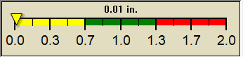
NWS forecast: Showers and thunderstorms likely before 4pm, then showers and thunderstorms likely. Partly sunny, with a high near 87. Southwest wind around 10 mph. Chance of precipitation is 70%. New rainfall amounts between a tenth and quarter of an inch possible.
Local station forecast: Mostly clear and cooler.
Tonight

Tonight: Showers And Thunderstorms Likely
Showers And T-Storms Likely

Lo 73°F
NWS forecast: Showers and thunderstorms likely before 10pm, then showers and thunderstorms likely between 10pm and midnight, then a chance of showers and thunderstorms between midnight and 1am, then showers and thunderstorms likely between 1am and 2am, then a chance of showers and thunderstorms. Mostly cloudy, with a low around 73. South southwest wind 5 to 10 mph. Chance of precipitation is 60%. New rainfall amounts between a quarter and half of an inch possible.
 NWS Short Term Weather Forecast
Sunday

Sunday: Chance Showers And Thunderstorms
Chance Showers And T-Storms
Sunday
Night
Sunday Night: Partly Cloudy
Partly Cloudy
Monday

Monday: Sunny
Sunny
Monday
Night
Monday Night: Clear
Clear
Tuesday

Tuesday: Sunny
Sunny
Tuesday
Night
Tuesday Night: Mostly Clear
Mostly Clear
Wednesday

Wednesday: Sunny
Sunny
Hi 93°F Lo 74°F Hi 96°F Lo 76°F Hi 97°F Lo 76°F Hi 96°F
ajax-dashboard6.php - Version 6.95h - 20-Feb-2023 - Script by: Scott of BurnsvilleWeatherLIVE.com
Now supported by Saratoga-weather.org Download