| NWS Weather Forecast -
Outlook Tonight & Tuesday |
Tonight

Partly Cloudy then Slight Chance Showers And T-Storms
Lo 76°F
|
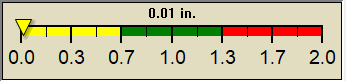
NWS forecast: A slight chance of showers and thunderstorms after 1am. Partly cloudy, with a low around 76. Heat index values as high as 105. Southwest wind 0 to 5 mph. Chance of precipitation is 20%. New rainfall amounts less than a tenth of an inch possible.
Local station forecast: Mostly clear and cooler. |
Tuesday

Chance Showers And T-Storms
Hi 97°F
|
NWS forecast: A chance of showers and thunderstorms. Mostly sunny. High near 97, with temperatures falling to around 93 in the afternoon. Heat index values as high as 110. West wind 5 to 15 mph, with gusts as high as 20 mph. Chance of precipitation is 30%. New rainfall amounts less than a tenth of an inch possible.
|
|
| NWS Short Term Weather Forecast |
|
Tuesday
Night

Chance Showers And T-Storms
|
Wednesday

Mostly Sunny
|
Wednesday
Night

Mostly Clear
|
Thursday

Sunny
|
Thursday
Night
Mostly Clear
|
Friday
Mostly Sunny
|
Friday
Night

Mostly Cloudy then Chance Rain Showers
|
|
Lo 70°F |
Hi 88°F |
Lo 66°F |
Hi 87°F |
Lo 65°F |
Hi 88°F |
Lo 68°F |
|
ajax-dashboard6.php - Version 6.95h - 20-Feb-2023 - Script by: Scott of BurnsvilleWeatherLIVE.com
Now supported by Saratoga-weather.org Download
|